The Challenge
The climate is changing faster than at any time in recorded history. Catastrophic storms, droughts, floods, fires, and high heat days are increasingly common. California experiences every one of these climate impacts, which can threaten California’s plants and animals
Plants and animals lack the ability to change their environment, and so, as their current habitat becomes unsuitable they may search out new, more suitable habitat to adapt to changing conditions. This type of movement may lead to shifts in their ranges. Range shifts have already been detected for many plant and animals in response to recent climate change. In California’s increasingly modified landscape, wildlife attempting to move to newly suitable habitat are likely to run into barriers such as roads, cities and sprawling developments blocking the way.
Given all these challenges, how do we protect California’s diverse and iconic wildlife as they move towards an uncertain future? With limited resources for protecting additional lands, the conservation community strives to plan for actions that protect wildlife in the present-day and ensure that those investments will lead to a resilient, biodiverse future. Innovation and technology are essential in this planning process to establish creative and effective solutions for conservation, today and in the future at spatial and temporal scales necessary for conserving species in a changing climate.
The Innovative Science
To help ensure that conservation decisions and investments are optimized for both current and changing climate conditions, The Nature Conservancy recently modeled the “state of habitat connectivity” for California. This analysis identified a continuum of existing connectivity opportunities, from broad intact landscapes to highly constrained linkages. Conservancy scientists then modeled the habitat linkages that would enable wildlife to move to adapt to changing conditions and lead to a more resilient, connected landscape.
The Technology
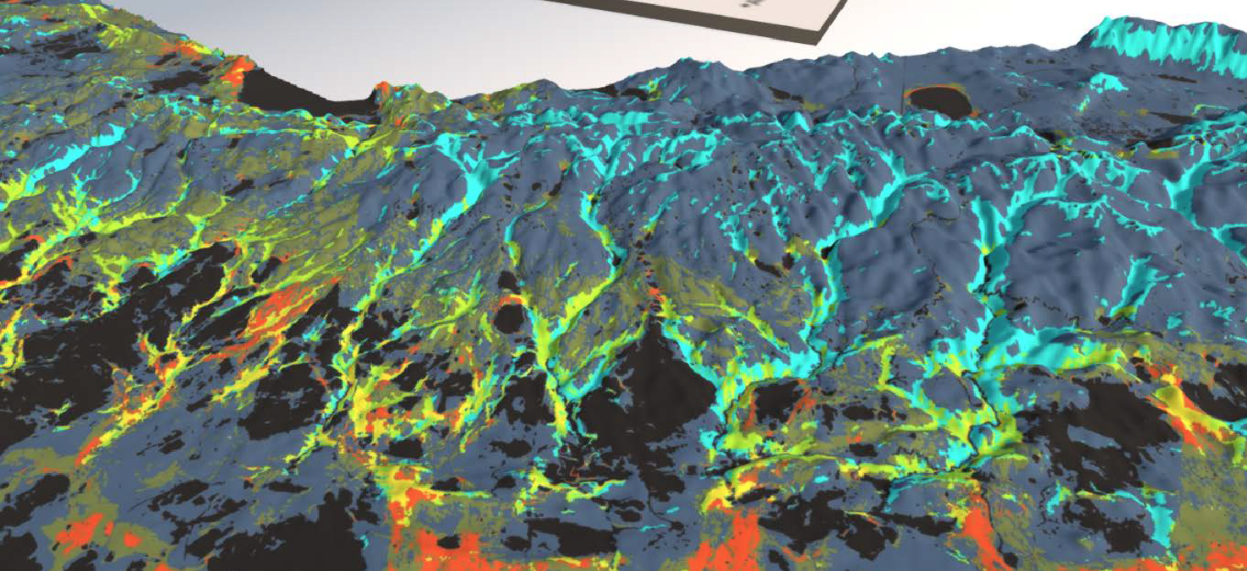
Using Omniscape, a novel modeling approach developed by Dr. Brad McRae, Conservancy scientists modeled connectivity between today’s climate and future similar climates. They incorporated topographic diversity and fragmentation patterns into the model to highlight resilient landscapes and habitat linkages that would facilitate climate adaptation. Incorporating this climate ‘lens’ to the ‘state of habitat connectivity’ helps to prioritize connectivity conservation actions by identifying ‘no-regrets’ pathways. This approach is the first to show a comprehensive picture of connectivity in California along with the movement pathways that connect current and future habitat. The conservancy also leveraged new technology to communicate the results in 3-dimensions. This visualization technology and platform makes apparent the importance of elevational gradients, topographic complexity, and riparian valleys essential for achieving a connected, resilient landscape.
Employing the Technology: Rainbow Canyon
The Conservancy is using this science to inform our key conservation and connectivity priorities. Early this year, the Conservancy acquired a critically important 73-acre parcel, the Rainbow Canyon property, which is situated along the Interstate 15 corridor in the Santa Ana to Palomar Mountains linkage in Riverside County, California. Interstate 15 serves as a nearly impenetrable barrier for wildlife travelling between the coastal Santa Ana Mountains and Palomar Mountains and other inland Peninsular Ranges.
The connectivity analysis confirmed that the Santa Ana to Palomar Mountains linkage is highly constrained, of state-wide importance, and a key movement route for climate adaptation. The acquisition of Rainbow Canyon resulting from this science and data collected in the field advances work toward a future wildlife crossing. Facilitating movement over this barrier will reconnect habitat on the east and west sides of the freeway for multiple species of plants and animals. This will help resolve genetic isolation of mountain lions in the area and provide pathways for species to access new habitat as they adapt to a changing climate.
Potential Future Application
This is just one example of how we are using this data. The technology will continue to be used to set conservation priorities within The Nature Conservancy. By providing a more holistic view of connective landscapes, it can be a critical tool for state agencies to use in setting their priorities and evaluating opportunities for a broader suite of conservation and land management actions.
 |
Alex Leumer, Climate Change Policy Analyst, The Nature Conservancy
Alex helps develop policy and projects focused on nature-based adaptation to climate change, with her main focus on the intersection of climate change and ecosystem conservation. Ms. Leumer holds a J.D. from Golden Gate University and a B.A. from the University of California, Santa Barbara. |
 |
Carrie Schloss, Spatial Data Scientist, The Nature Conservancy
Carrie focuses on multi-benefit conservation planning and climate change adaptation. She uses data analytics and creates decision support tools to encourage the integration of conservation values across sectors. She explores how natural resource and social science information can be combined to reveal new opportunities to advance the conservation of natural lands in an urbanizing landscape. She also conducts statewide assessments that identify how the landscape can enhance resilience and adaptation to climate change to support climate-smart conservation decisions. |
 |
Cara Lacey, Associate Program Director, Land Networks, The Nature Conservancy
Cara A. Lacey is an urban and regional planning professional with over 18 years of experience. She currently serves as the Associate Program Director for the Land Networks Program and as the Connected Lands Strategy Lead with The Nature Conservancy. |